Newfoundland
Posted by Greg on March 27, 2008
Expedition completed on July 29, 2008
Newfoundland Blog Entries (click on this link to read the daily blog entries from the circumnavigation).
Total distance paddled: 2102K (1306 miles)
Daily average: 60.05K (37.3 miles)
Longest day: 93K (57.8 miles)
Shortest day (aborted crossing of Trinity Bay): 27K (16.7 miles)
Total days: 44
Paddling days: 35
Weather/Rest days: 9
This trip was an amazing experience. I’m not sure what was most impressive, the coastline and wildlife (many whales and dolphins) or the hospitality of the Newfoundlanders. Their willingness to reach out and help, and genuine care and concern, was most appreciated. I will definitely make plans to be back in the future!
What: Unsupported solo Newfoundland Circumnavigation (approximately 1700 miles)
When: June, 2008 planned start date
Trip goal: a fast and exciting circumnavigation of Newfoundland. I plan to push myself and enjoy headland to headland paddling, but also take enough time to enjoy the sea caves, birds, and the areas of quiet beauty — bays and historic sites, including the ancient Viking settlement at L’Anse aux Meadows.
Gear: I will be paddling an NDK Greenlander Pro, and will use two Superior Kayaks 2-piece carbon Greenland paddles, in 86″ and 88″ lengths. If ordered custom Mark Rogers can construct the paddles so that you can combine them in any combination. For example, I can select from an 86″, 87″ or an 88″ assembled paddle. This gives a great deal of flexibility to tune the paddle to the conditions and your strength level. I will be using a Kokatat Gore-Tex Expedition Drysuit and will experiment with wool base layers for the first time. I will be using a Snapdragon skirt and cockpit cover and North Water deck bags, towline and paddle leash. I’ll publish a full list of my kit, including camping gear when the trip is done.
For some kayaking images of Newfoundland, please see my album of kayaking the Avalon Peninsula in 2007.
I will be sending a daily status of my trip to this blog.
Karel Vissel will be providing me with weather forecasts sent to my (rented) Iridium satellite phone. I will send daily updates to Karel via text messages from the sat phone and Karel will relay the messages and also provide Google maps of my progress to my family, close friends, and also to Derrick Mayoleth.
Derrick will blog my daily updates here, except for the occasions when I can find Internet access and post a message (and pictures) directly. While I am greatly looking forward to meeting as many folks as possible on my trip, I expect to be spending most of my time camping in the wilds, rather than in towns. But that Newfoundland hospitality might quickly spoil me….
Karel and Derrick many thanks for your offer to help! Please let me return the favor, soon.
Many thanks to Wendy Killoran for generously providing me with the maps she used on her successful 2006 circumnavigation.
I would love to receive comments from folks in Newfoundland (including my friends from the KNL Retreat) and others who have paddled there. Hopefully you can help me with some of the following questions. I have already received some excellent advice from Neil Burgess and Richard Alexander.
What are the beautiful scenic spots that I just shouldn’t pass up?
Do you have some local knowledge that you would be willing to share to help make my journey more safe or enjoyable? Hazards? Currents? Blackflies? Local history? Scenic spots?
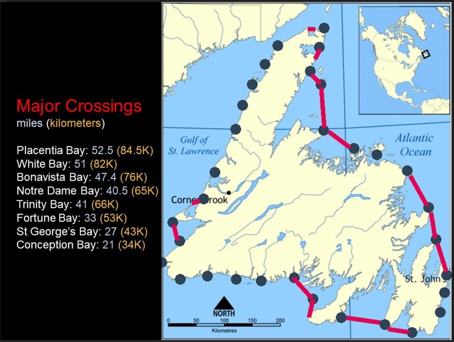
I’m still examining the data regarding a clockwise or counterclockwise journey. My current plans are for a clockwise circumnavigation starting from St. John’s, to hit the south coast during the prevailing easterlies (and before the wind changes to southerlies). All comments are welcome.
Thanks in advance for your advice, comments and support!

