Archive for the ‘Newfoundland2008’ Category
Posted by derrick on
June 26, 2008
From Greg: Hunkered down in strong, gusty winds. Sea is a mess of whitecaps. Hìlleberg tent doing a great job. Hiked island and replenished water from large interior lake. No sign of lone bison reported in past years. Landscape is green rolling hills, untamed by fences & replenished and bordered by the sea. Stunning & soul renewing.
(Force 7? White Caps? and he’s on land communing with nature?? Bah! I say!. . . .)
Posted by derrick on
June 25, 2008
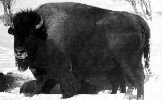
Brunette Island, 20 km2, is situated at the mouth of Fortune Bay on Newfoundland’s Southern coast, 18 km South of Connaigre Head. Residents of the Island were relocated to the mainland in the late 1950s, and since then Brunette became a provincial wildlife reserve. Over the years the government has started experimental colonies of Caribou, Arctic Hare, Moose and . . . Bison. Apparently they all lived happily ever after. . well, other than the bison.
Greg arrived on Brunette Island under heavy fog and light rain. He fully guyed out his tent in anticipation of storms and winds up to F7 plus tomorrow. Sounds like a weather day. He reports that a whale spoutedd close to his kayak today. . . and that he’s looking forward to sleeping in. . . all cozy warm in his tent. . . curled up with a Caribou, an Arctic Hare, a Moose, and a Bison. . .

Read More about Brunette Island.
*top image by John Hill, 1971.
Posted by derrick on
June 24, 2008
From Greg – heavy, dense fog. Only dark glimpses of land. Light winds. Saw a small whale! Paddled late into the night due to the lack of landing spots. Covered 57k.
Posted by derrick on
June 23, 2008

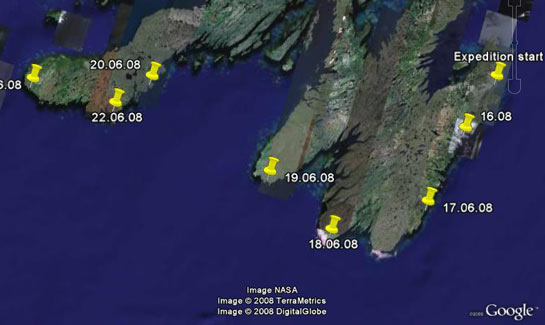
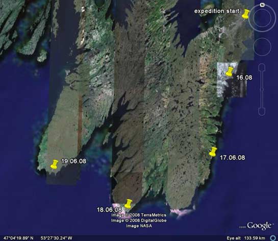
After a rest day Greg jumped right back into the fray. He battled intense F5 plus headwinds and for most of the day made only 1 to 2 kts. The constant cold winds caused both his contact lenses to dry out at the same time and roll behind his eyelids. He had to switch back to glasses (which can really suck on the water). Through the day the wind and fog would sweep rapidly over and then plummet down the mountain peaks which Greg said was amazing to see. The wind died around 5pm. By the end of the day he made a camp in a small cover near Sauker Hd by a small stream. For the day he managed 33 km.
– if you look really closely, you can see Greg skinny dipping in the fridged stream. . . . (N46 54.5 W55 17.9)
Posted by derrick on
June 22, 2008
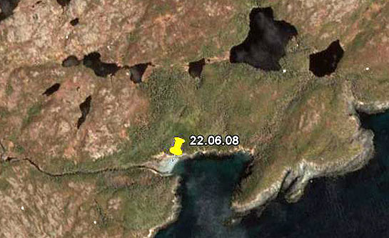
Greg checked in with a bit more yesterday – “Resting in Fox Cove. Placentia crossing started with steep following seas. 93km. Was able to surf for the beginning of the trip near Cape St. Mary’s. GPS recorded highest surfing speed of 18.9kts. Winds died midway into crossing Paddled thru the night, and then sun-up (the sun sets around 9:30pm and rises around 4:00am). Bright flashes of bioluminescence on each paddle stroke.”
Posted by derrick on
June 21, 2008

Placentia Bay is about 50 miles wide stretches inland about 80 miles. We had wondered how Greg would approach it. Now we know. We received a late message; “N47 05.5 W055 06.3 Crossed Placentia Bay 18 hours in kayak. Will take a rest day.” A rest day? I’m not surprised! 18 hours across open water is an incredible achievement for any paddler. We’re all pretty impressed around here, and of course happy Greg made it across without incedent. Neil Burgess shares this; “No one has ever crossed Placentia Bay from Cape St. Mary’s to the Burin Peninsula before in a kayak!”
Posted by derrick on
June 20, 2008

(Point Lance)
Yesterday Greg Crossed St. Mary’s Bay coping with strong currents and quarting winds the whole way. He is now staying in Point Lance (population 119), under the care of Orinda & Jerry. N46 48.7 W54 05.1 – 53K day.
St. Mary’s Bay is about 25 miles wide and 36 miles deep and lined with many small communities. For a bit of history about life on the bay read:
– Branch, St. Mary’s Bay in pre-confederation Newfoundland
– History of St. Mary’s
Message from Greg: I was greeted by Benedictine on an ATV as I sorted my gear. The residents remember Freya and I landing in the town last year to use the phone at “Bennie’s” house. Many thanks to Jerry and Orinda for their hospitality! Not only did they give me a fine dinner, a warm bed, and breakfast but Jerry drove into town to purchase some marine caulk to use for kayak repairs. Jerry refused any payment and I will never forget their kindness.
Posted by derrick on
June 19, 2008
From Greg: N46 37.2 W53 32.7 Westward ho! Rounded Cape Race and crossed Trepassey Bay. 70km. Many seals. Beautiful moonrise over sea.
—————————-
Each day I as soon as I open my email I see our new map and update from Greg waiting. . thanks Karel! It’s amazing what you can do when you have people working on the same projects from a variety of time zones!
* top image: Library of Congress
Posted by derrick on
June 18, 2008
From Greg Today:
N 46 52.7 W52 56.1 Cappahayden. Early fog turned to sun. Seas much calmer. Huge iceberg in Renews Hbr. Enjoyed some “fizzing” 3,000 year old ice, originated as snow in Greenland, plucked from the water as I paddled. Camp on ridge overlooking sea.
—————————————
56.1 Kilometers comes out to about 35 miles. So. . Here’s today’s trivia: Cappahayden is actually half of an amalgamated fishing village now called Renews-Cappahayden with a population of about 400 or so. If you Google “Cappahayden” you’ll find that Cappahayden dating websites come in at #5 & #10 in the search. And wouldn’t you know, Greg spent the night up on the ridge. . .
Posted by derrick on
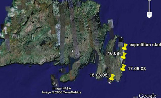
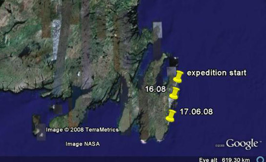
June 17, 2008
Greg checks in. . .
N 47 17 W 52 48. 40KM. Quidi Vidi to Witless Bay. Lumpy, confused seas. Challenging along Cape Spear & cliffs to south. Rain and light fog. 3 icebergs in view thru tent door.
—————————
Greg is using a SAT Phone along the way to keep us up to date. Designed a bit like a 1980’s cellphone it takes forever to just key out short messages. By the way, in case you were curious Witless Bay is not a commentary on the residents. The story goes that Captain Whittle and his family from Dorsetshire, England founded the community. Then on his passing his family returned to England. Hence, the remaining settlers referred to Whittle’s Bay as Whittle less Bay and eventually, Witless Bay. Well, maybe that’s a bit of reach but that’s what the guidebook says!